ST. CATHARINES LOOP (40 KM)
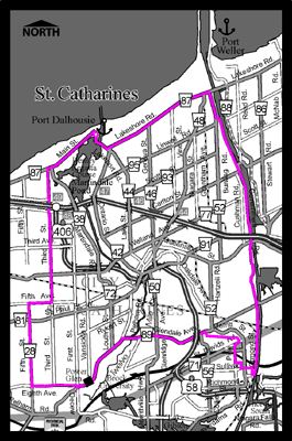
This loop takes you right around the City of St. Catharines and along the Welland Canal into Thorold. As you follow the canal, watch for boats and stop at Lock Three for a good look at the Lock and visit the St. Catharines Historical Museum.
Coming down from Thorold on Bradley Street you will be beside the Second Welland Canal, used in the mid-1800’s. On the west side of St. Catharines, you will pass close to two wineries and the famous Wiley’s Juice factory.
You may travel on parts of the Waterfront Trail and the Welland Canals Parkway if you wish. This route stays on roads, but to follow the Waterfront Trail through St. Catharines, follow the signs. Watch for the Welland Canals Parkway Recreational Trail on your left as you follow Government Road from Lakeshore Road to Glendale Avenue. Glendale Road from Mountain Road to Pelham Road is busy, but there are bike lanes almost all of the way.
Thanks to the RNBC for providing this map.
CLICK HERE TO DOWNLOAD THIS MAP IN PDF FORMAT.
Some of the information presented on this site involves various routes and trails that many Niagara Cyclists use everyday. We can not take any responsibility for any accidents that may happen when using these routes. As always, ride responsibly!
Featured Community Builder
Featured Community Partner
Proud Members of:
![]()
Niagara Cycling Categories
Below is a list of categories available through our Cycling Guide. Please click here to add your business to our listings.